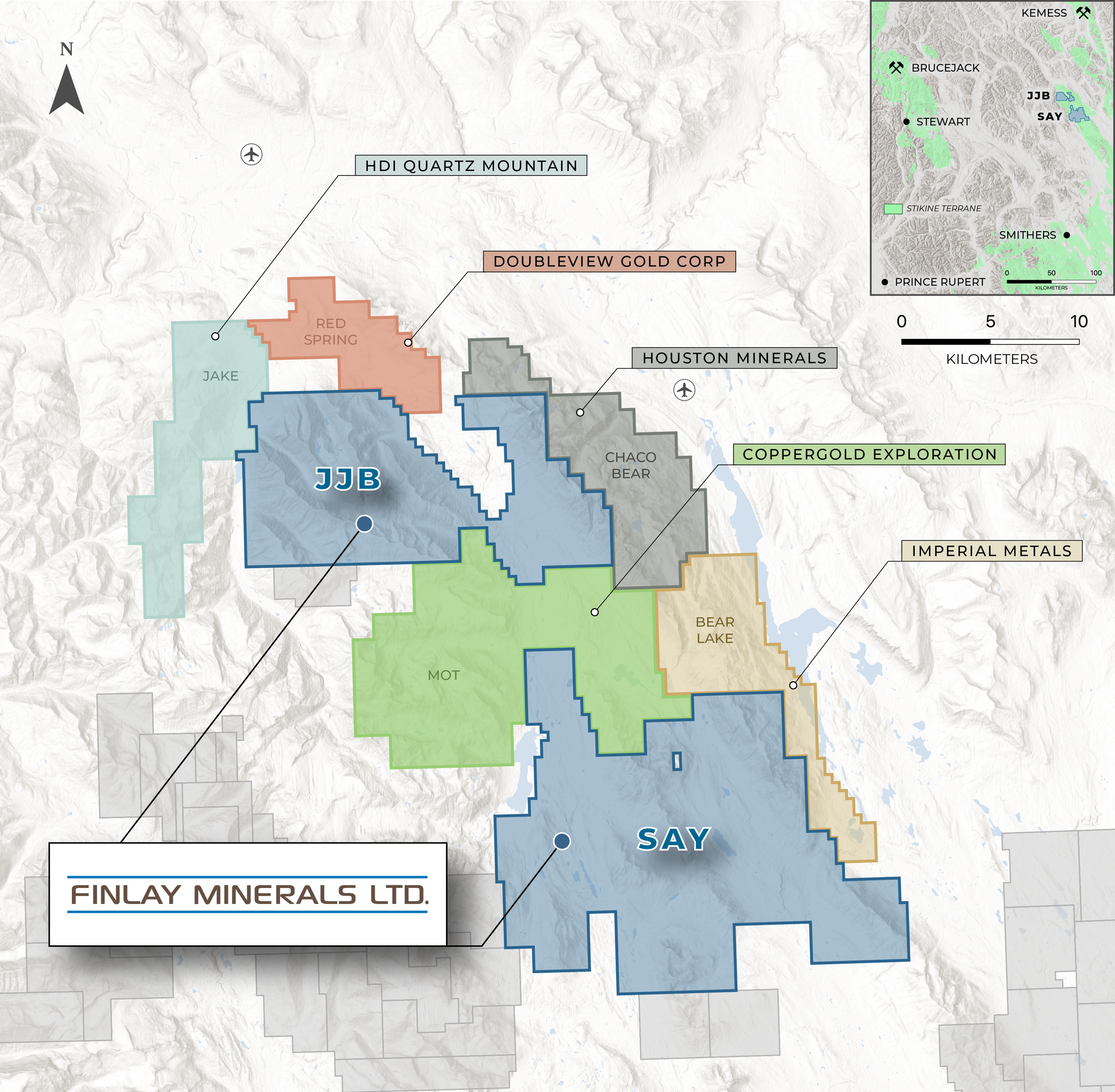
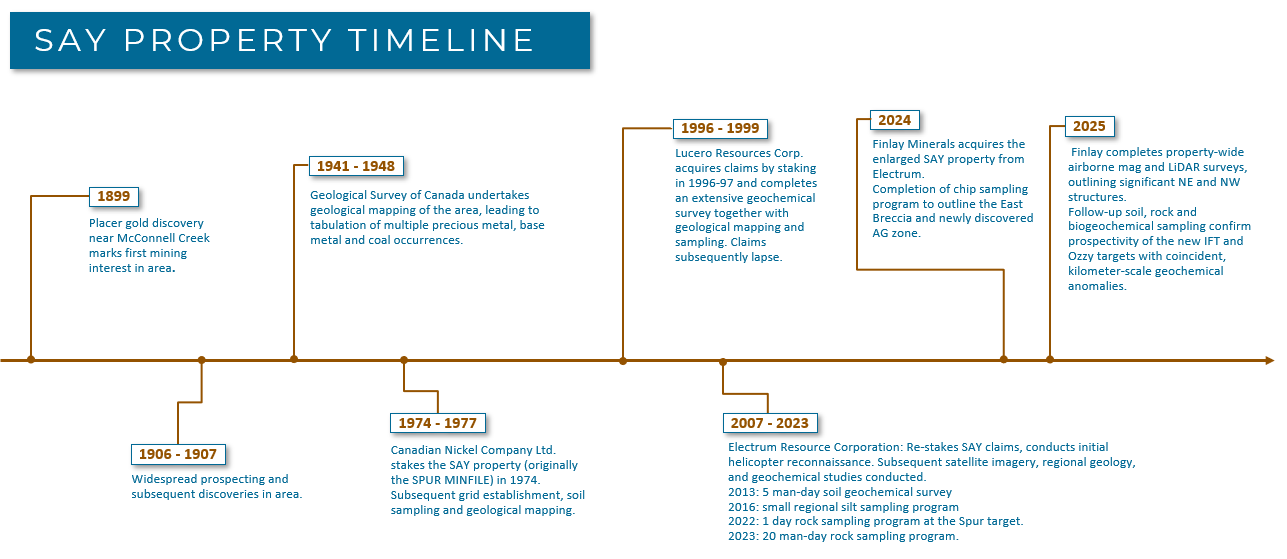
Finlay’s 100%-owned SAY Property covers 26,202 hectares (262 km2) of highly prospective Stikine Terrane, 140 km north of Smithers B.C. The Stikine Terrane is a tectonic assemblage that hosts the metal endowment in B.C.’s Golden Triangle, the Toodoggone District, and the Skeena Arch. The SAY Property straddles the western margin of the relatively underexplored, 135-km-long, “Driftwood Corridor” of Stikinia, a tectonic position analogous to American Eagle Gold’s Nak Cu-Mo ± Ag ± Au porphyry prospect, 90 km to the south. The Driftwood Corridor hosts several volcanic redbed / sediment-hosted Cu ± Ag showings and prospects including the Copperline and Red Spring prospects. Porphyry prospects throughout the region are associated with post-accretionary Cretaceous – Eocene intrusions in both Stikinia (e.g. Imperial Metal’s Cu-Mo Porphyry Bear Lake Project) and overlying Bowser Basin sediments to the west (e.g. HDI Quartz Mountain’s Cu Porphyry Jake Project).
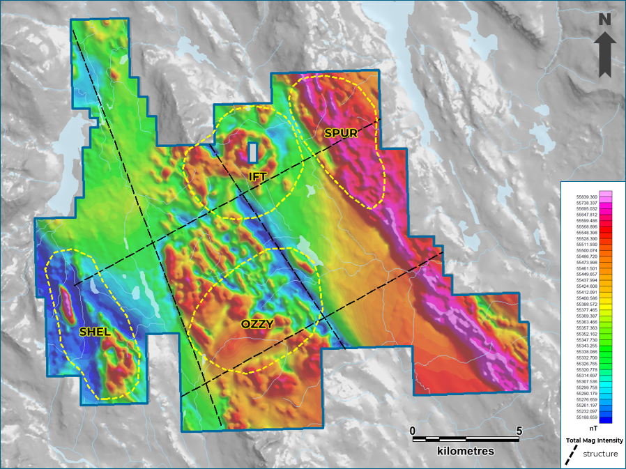
Recent work on the SAY Project has outlined three new high-grade Cu + Ag target areas at IFT, Ozzy and SPUR and one Cu-Mo porphyry target area at Shel. These targets have been identified using airborne mag and soil, rock and biogeochemical sampling.
There is road access to the southeast end of the property, and helicopters are used to access the rest of the SAY Property.
The exploration program in 2026 is fully-funded to complete Induced Polarization geophysical surveys over the IFT and Ozzy targets with additional mapping, soil sampling, and biogeochemical programs at the IFT, Ozzy and Shel targets
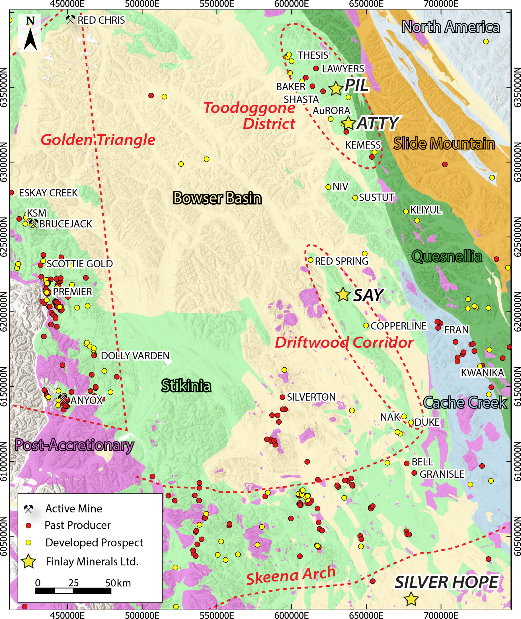
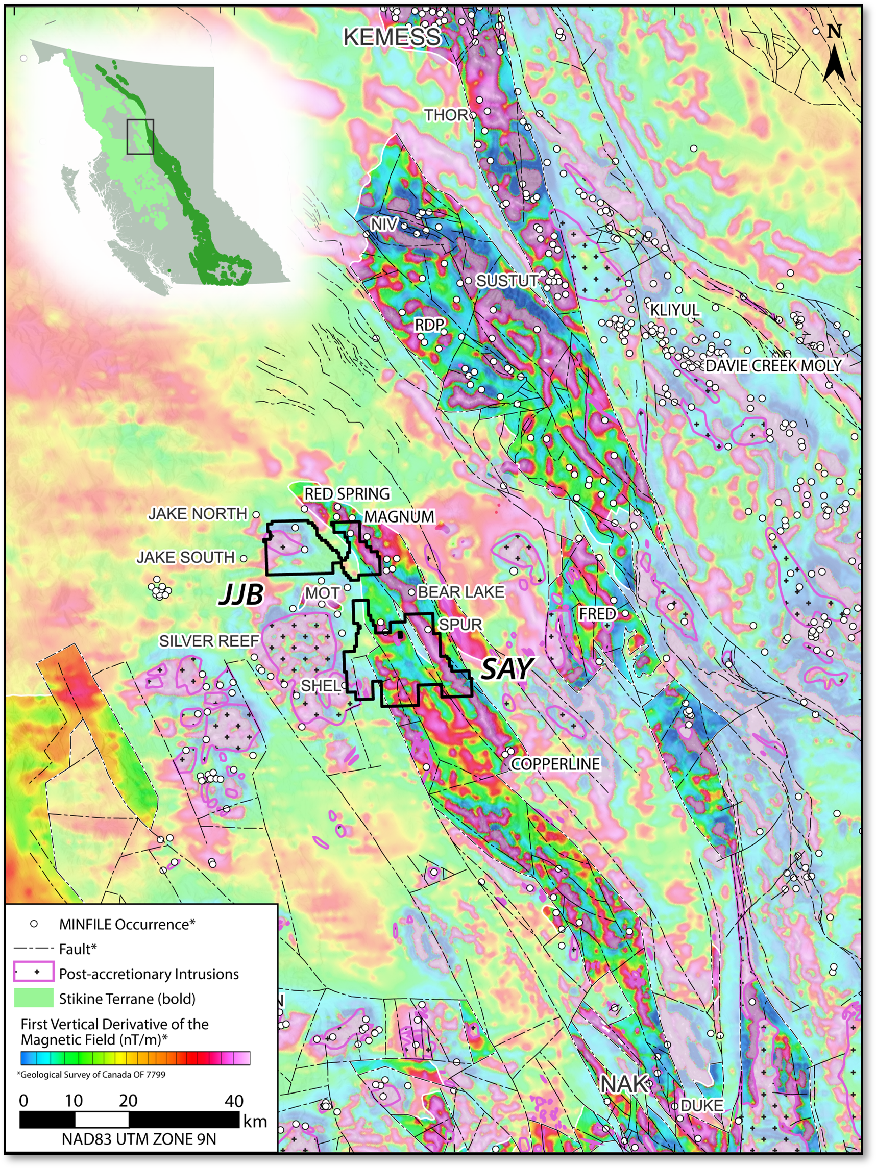
The SAY Property is located along a 55-km-long, north-northwest-trending, strong magnetic high that hosts several showings and prospects. Projects in the broader region, including the Toodoggone, have demonstrated size potential:
RED SPRING, Sediment Hosted Cu-Ag: 5.0 Mt at 0.5% Cu and 11.9 g/t Ag (1985 non-NI43-101-compliant)
COPPERLINE, Volcanic Red Bed Cu-Ag: 0.9 Mt at 2.0% Cu and 48 g/t Ag (1990 unclassified estimate; non-NI43-101-compliant)
KEMESS SOUTH, Cu-Au +/- Ag-Mo Porphyry, Past Production: 750 M lbs Cu & 3.0 Moz Au from 218 Mt.
SUSTUT COPPER, Volcanic Red Bed Cu: 8.561 Mt with an average of 1.615% Cu* (0.65% Cu cut-off; 2003 non-NI43-101-compliant).
NAK PROPERTY, Cu-Au-Mo Porphyry: Drill hole NAK23-17 with 302.1 m of 0.40% Cu, 0.53 g/t Au and 0.046% Mo from 166.9 m
*See bottom of page for sources.
2025 Airborne Magnetics
Over 1,200 line-km of airborne magnetics was completed during the 2025 field season providing detailed coverage of the SAY property.
Airborne magnetic surveys are a useful exploration tool for porphyry deposits, which generally exhibit characteristic alteration aureoles with associated geophysical responses. The results of the 2025 survey show favourable signatures for porphyry mineralization and cross-cutting linear structures on the SAY property:
Sources:
Kemess South Past Production:
https://www.centerragold.com/operations/kemess-project/kemess-east/
American Eagle Gold NAK23-017 Drill Results:
https://americaneaglegold.ca/news/american-eagle-intersects-302-metres-of-1.09-copper-equivalent-within-606-metres-of-0.74-copper-equivalent/
Sustut Copper 2003 Mineral Resource Estimate (Non-NI43-101-Compliant):
https://minfile.gov.bc.ca/Summary.aspx?minfilno=094D++063
Red Spring Project 1985 Historic Mineral Resource Estimate (Non-NI43-101-Compliant):
https://minfile.gov.bc.ca/Summary.aspx?minfilno=094D%20%20104
Copperline Project 1990 Historic Mineral Resource Estimate (Non-NI43-101-Compliant):
https://minfile.gov.bc.ca/Summary.aspx?minfilno=093M++117
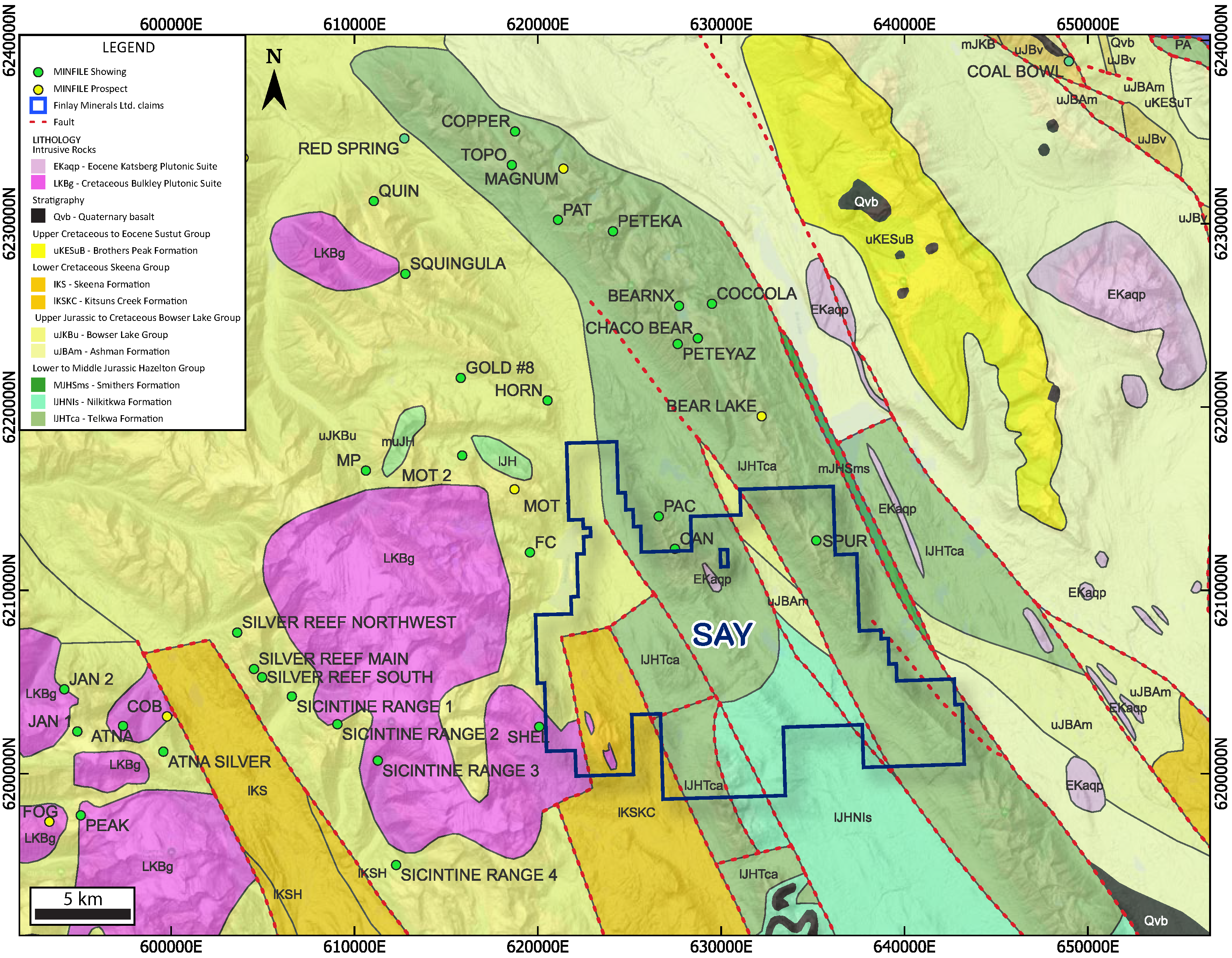
The SAY Property is underlain predominantly by a NNW-trending corridor of the Stikine Terrane. The assemblage hosts several significant Cu ± Au ± Mo porphyry and associated Au ± Ag vein deposits in the Golden Triangle of Northwest B.C., in the Toodoggone district, and in the Skeena Arch of central B.C. The volcanic and sedimentary stratigraphy underlying the SAY Property belongs to the Telkwa Formation of the Lower Jurassic Hazelton Group.
Adjacent to the Hazelton Group stratigraphy, slivers of post-accretionary onlap sediments of the Upper Jurassic Bowser Lake Group and Lower Cretaceous Skeena Group are bound by faults, which may have provided pathways for mineralizing fluids.
Small felsic to dioritic intrusions in the vicinity of the SPUR showing may be assigned to the Eocene Katsberg Plutonic Suite, while stocks on the west property margin at Shel are Cretaceous Bulkley Plutonic Suite. Porphyry-style mineralization in the region is genetically associated with both the Katsberg Suite (e.g. Bear Lake Project, Imperial Metals) and the Late Cretaceous Bulkley Plutonic Suite (e.g. JAKE Project, HDI Quartz Mountain).
In the Cretaceous and onwards, the region was subject to significant dextral transpression, which is largely responsible for the dominant NNW-trending structural fabric throughout B.C. Stratigraphy on the property is cut by dominant north-south structures and lesser northwest structures. These north-south structures exhibit possible control on the SPUR showing mineralization. A major north-south structure has been mapped regionally bisecting the property.
Structurally and stratigraphically hosted Cu-Ag mineralization in the Hazelton Group and porphyry-style Cu-Mo associated with Cretaceous and Eocene intrusions on the Property provide viable exploration targets.
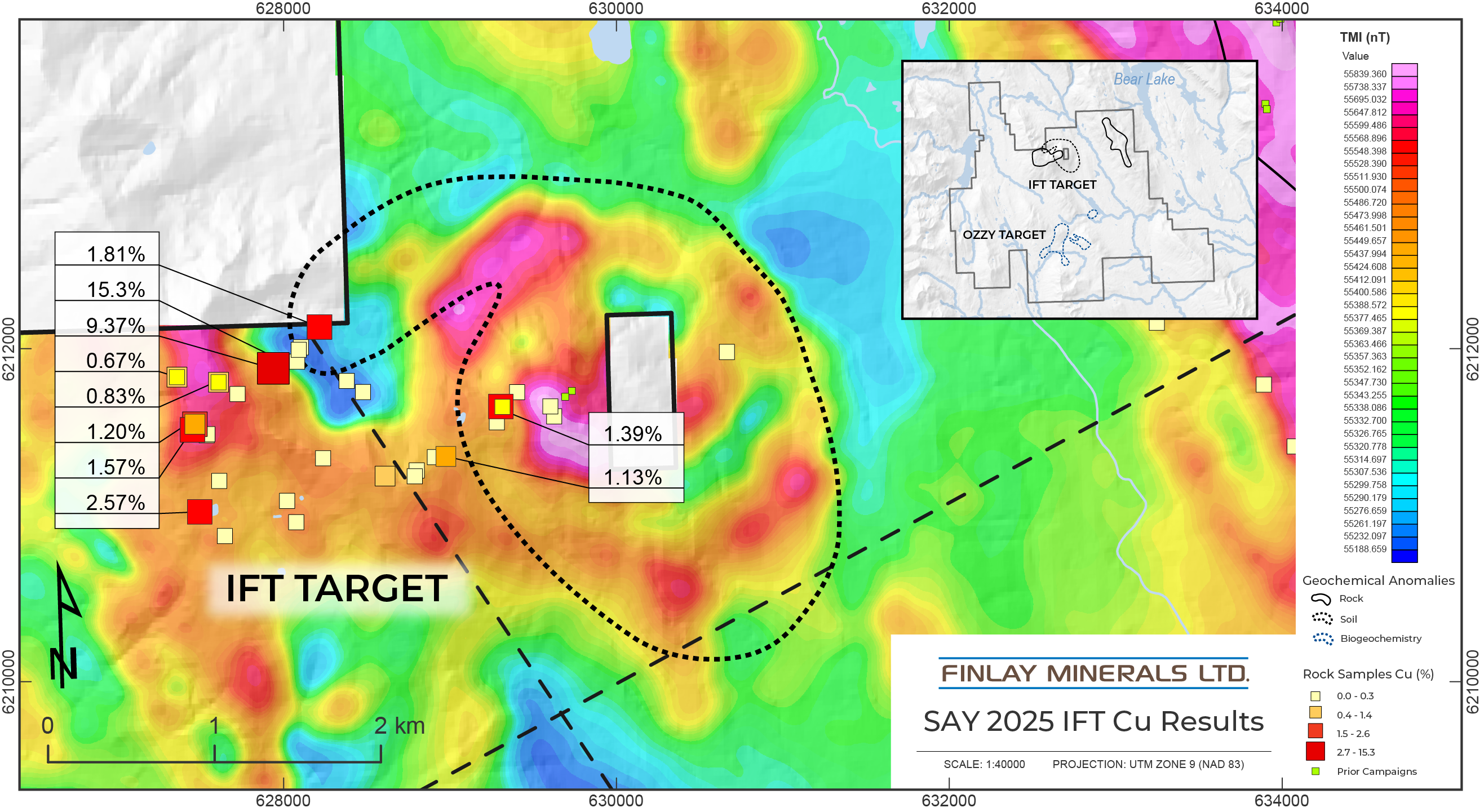
While much of the SAY property remains to be explored, the airborne mag survey completed in 2025 successfully generated two new target areas, IFT and Ozzy, and supported earlier interpretations of the previously identified SPUR and Shel Targets. The viability of these targets were later confirmed by mapping, rock, soil and biogeochemical sampling, which identified copper and silver mineralization with associated alteration minerals.
IFT
The assay results from soil sampling and mapping demonstrate that the IFT is a viable porphyry target. Soil sampling in 2025 along the eastern portion of the IFT identified a 1,700 m x 2,600 m Cu + Ag + As + Bi + Mo + Te geochemical anomaly synonymous with porphyry deposit environments. The soil geochemical anomaly occurs within the large circular magnetic anomaly encompassing the IFT showing in an area that is predominantly devoid of outcrop. Mapping and rock sampling in 2025 outlined a Cu and Ag mineralized area of 1,700 m x 1,000 m. Mineralization occurs as massive sulphides and lenses disseminated in wall rock as well as fracture-fill and veins. Chalcopyrite and bornite are the dominant copper-bearing sulphides analogous to the SPUR target to the east. Mapping, geochemical studies and geophysical signatures display characteristics commonly associated with porphyry mineral systems.
OZZY
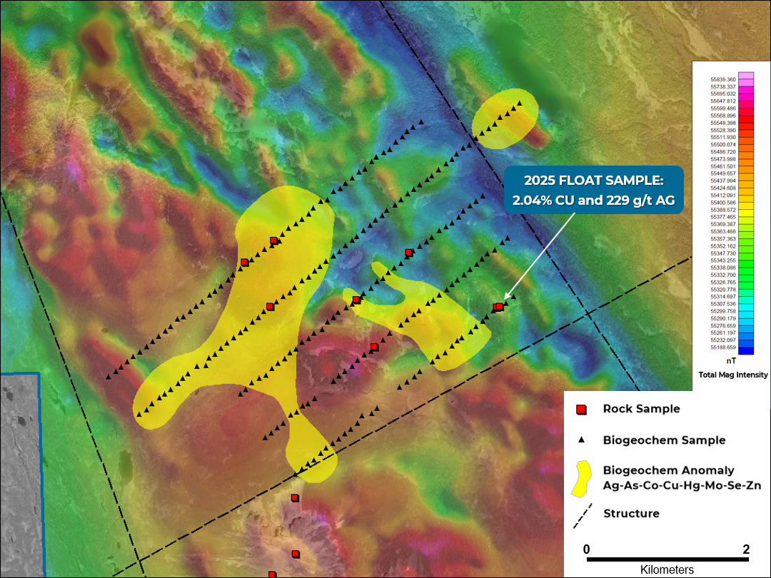
The Ozzy target is located at the intersection of prominent northeast and northwest-trending mag anomalies that were identified with the 2025 airborne mag survey. These mag features are interpreted as structures.
Due to limited outcrop exposures and thick till, five 600 meter-spaced lines of biogeochemical samples were planned to test the mag anomalies at Ozzy in 2025. The sampling has outlined two distinct, kilometer-scale, Ag-As-Co-Cu-Hg-Mo-Se-Zn anomalies over these magnetic highs with results supported by surface soil and rock sampling to confirm the effectiveness of the biogeochemical sampling. To the east of the biogeochemical anomaly, an andesite float sample with calcite-bornite-malachite veining assayed 2.04% Cu and 229 g/t Ag (J606727).
The southern Ozzy area contained strong visual manganese alteration of sedimentary and volcanic rocks. Chlorite alteration is prevalent with patches of silica and sericite. Mineralization is dominated by pyrite with no magnetite present; veining is dominated by carbonate and quartz.
Further sampling is required to test the extents of these anomalies to the north, east, south and west.
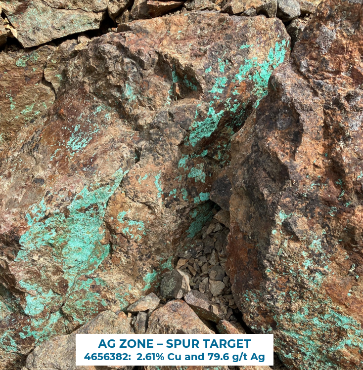
SPUR
The SPUR showing is associated with disseminated and structurally hosted chalcopyrite, bornite, chalcocite, covellite with minor pyrite, occasional galena and native Cu. Malachite and azurite occurs on fractures and weathering surfaces, and as vesicle fill. High-grade, predominantly structurally hosted Cu and Ag mineralization (up to 15.8% Cu in sample H624033 and 993 g/t Ag in sample SAYPR015*) has been sampled over 4.3 km along the NNW-trending Tsaytut Spur ridge. To date, 78 of 136 rock samples collected contain >1% Cu & 59 samples contain >100 g/t Ag.
*BC Mineral Assessment Report 30028
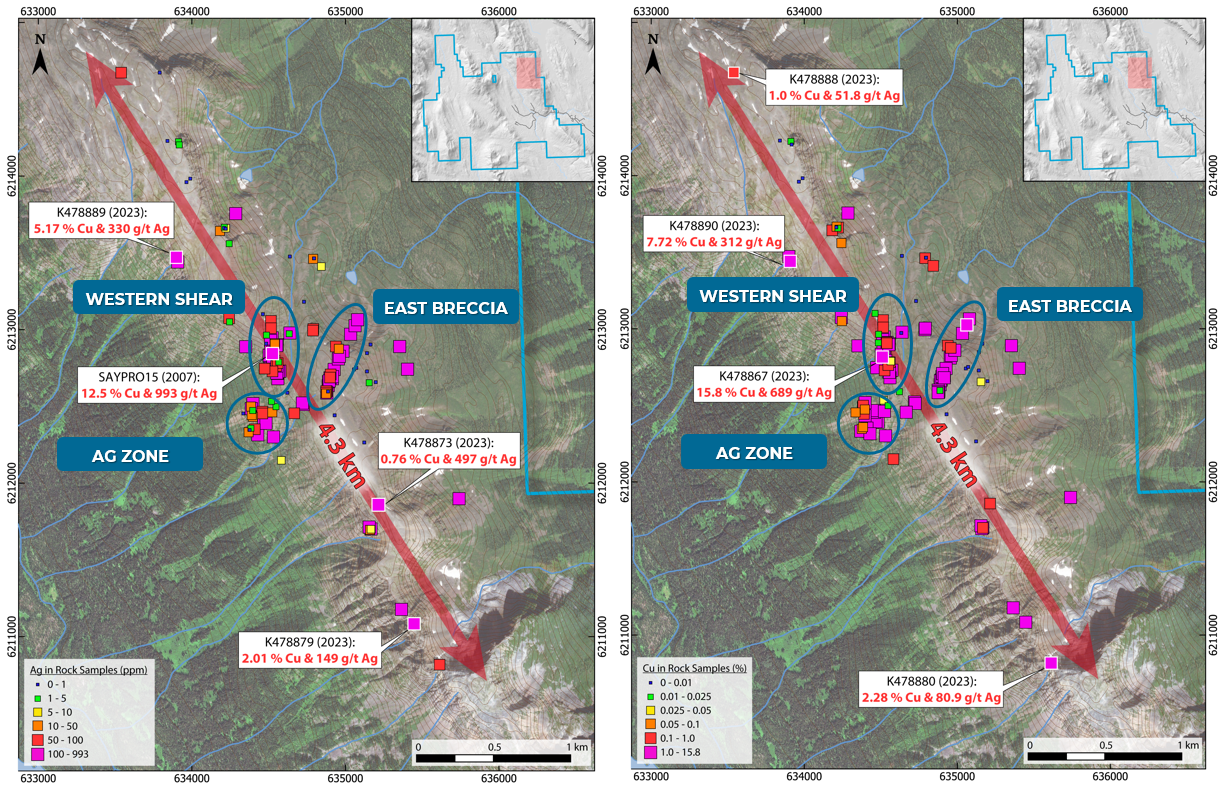
The following mineralization styles have been observed in the SPUR target area:
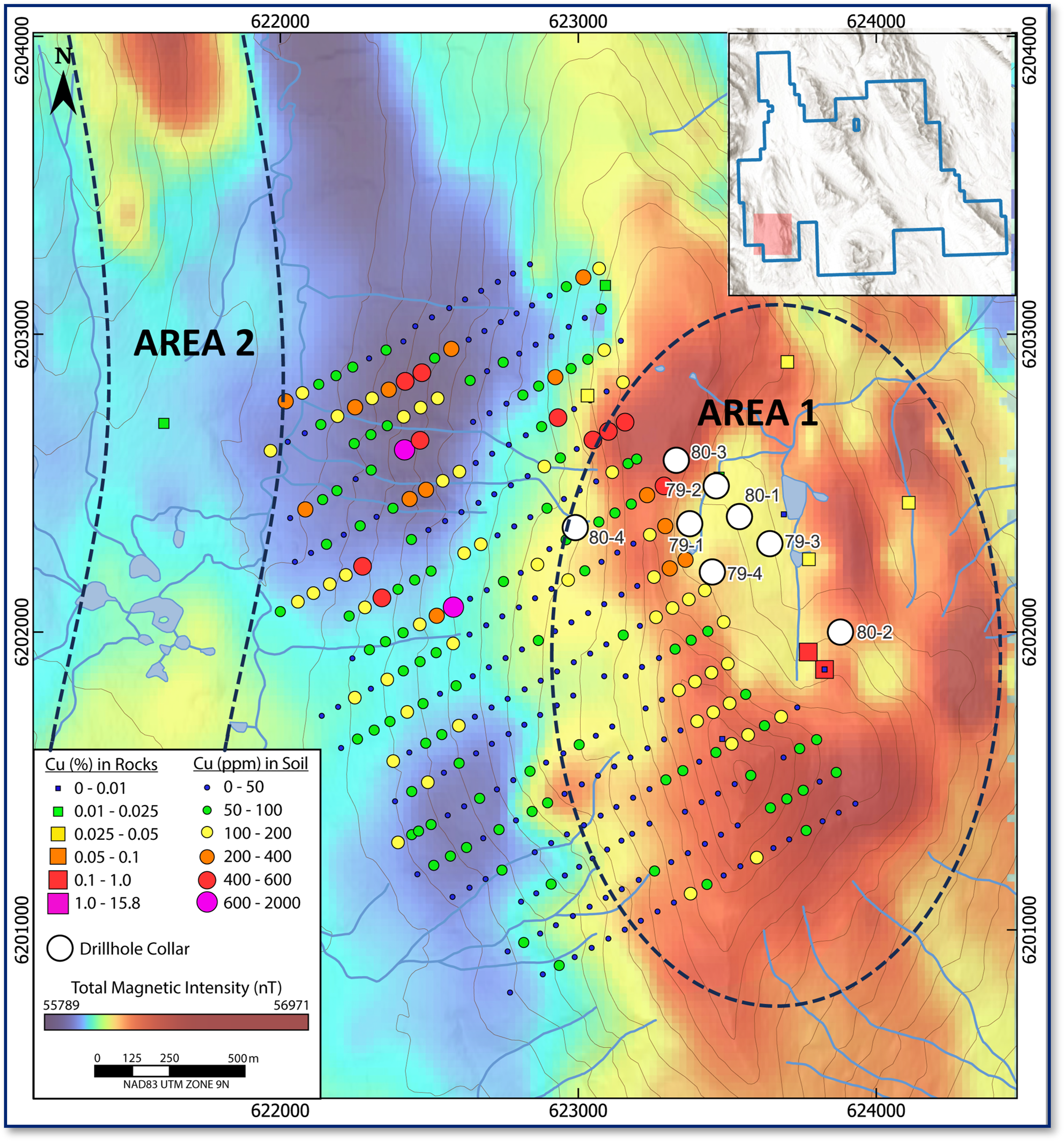
SHEL
The SHEL target is broadly gossanous with abundant orange and red iron-stained rocks present over ~2.5 x 1.5 km of exposed outcrop in the centre of the area. Mineralization is associated with quartz-feldspar porphyry dikes and includes chalcopyrite-molybdenite in quartz veins and in emplacement breccias along the dike margins.
Historic rock samples in the area yielded up to 1147 ppm Mo and 0.19% Cu (BC Mineral Assessment Report 30404). Shallow historic drillholes (8 drillholes for 1,616 m, maximum depth of 258 m) intersected weak Cu-Mo mineralization over tens of metres. Drillhole 79-2 intersected 59.3 m assaying 0.08% Cu and 0.107% Mo from 77.7 m (BC Mineral Assessment Report 8075). Historic exploration and geochemical anomalies lie on the western margin of a largely unexplored elliptical 3 x 2 km magnetic high.