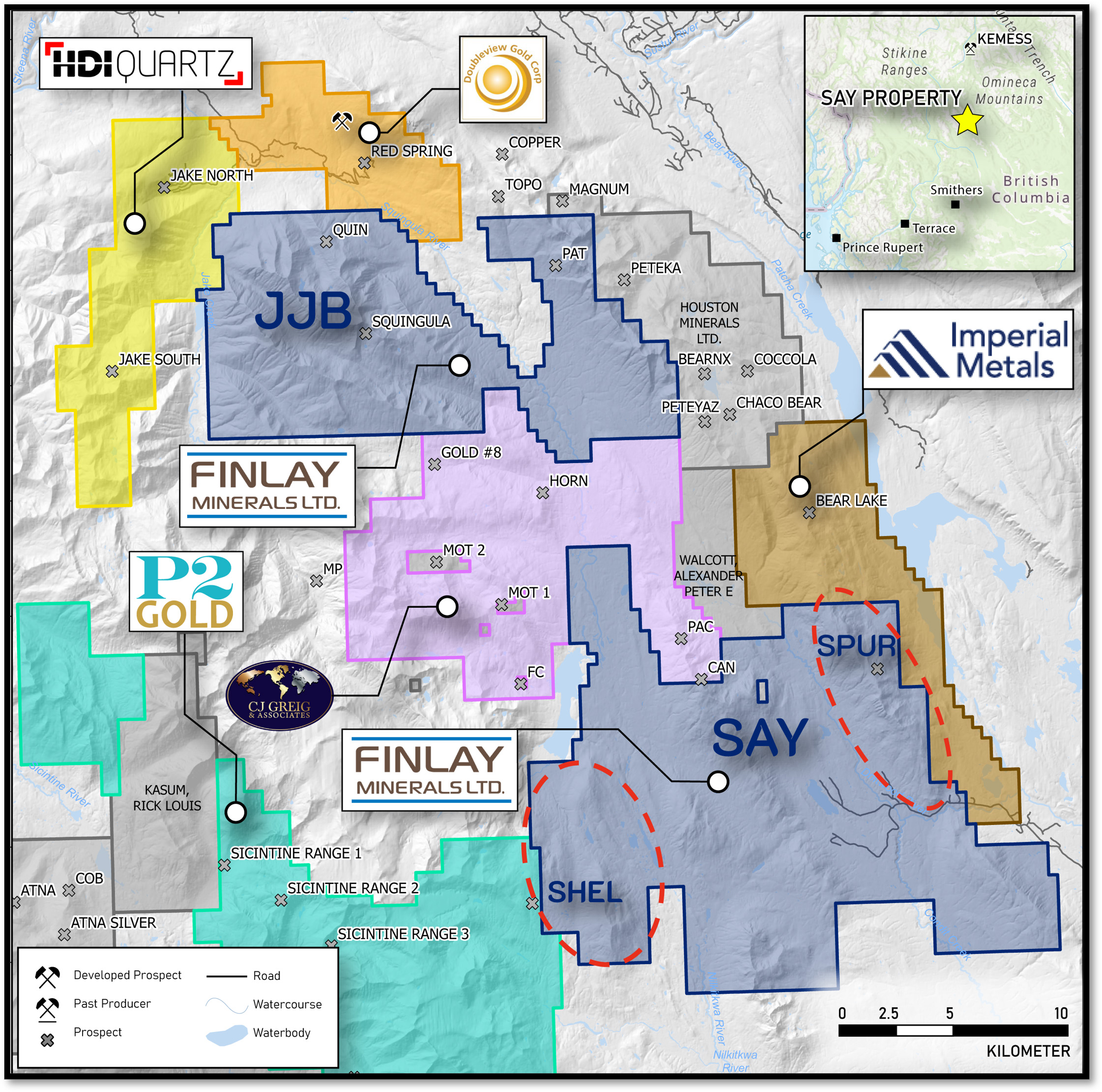
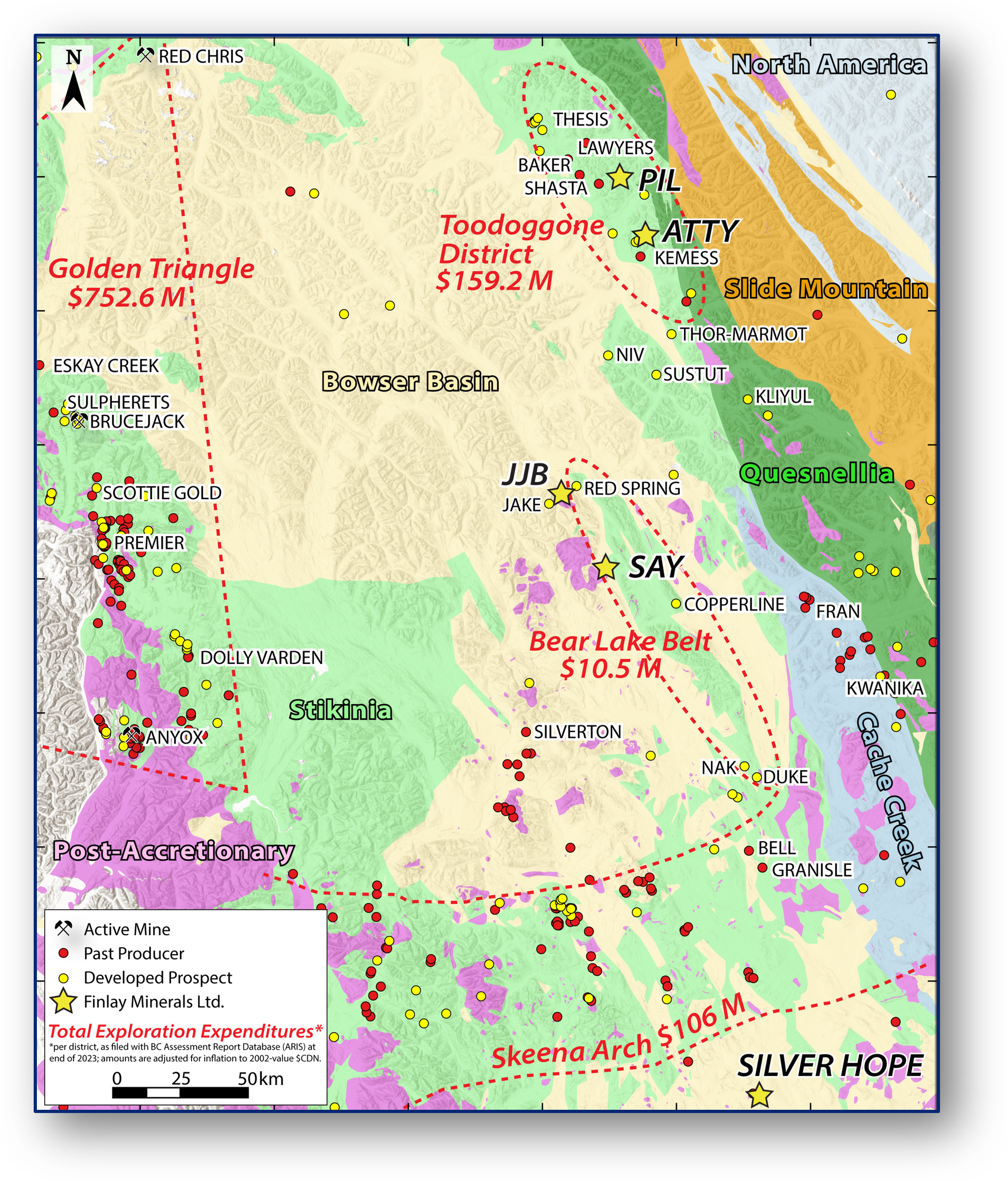
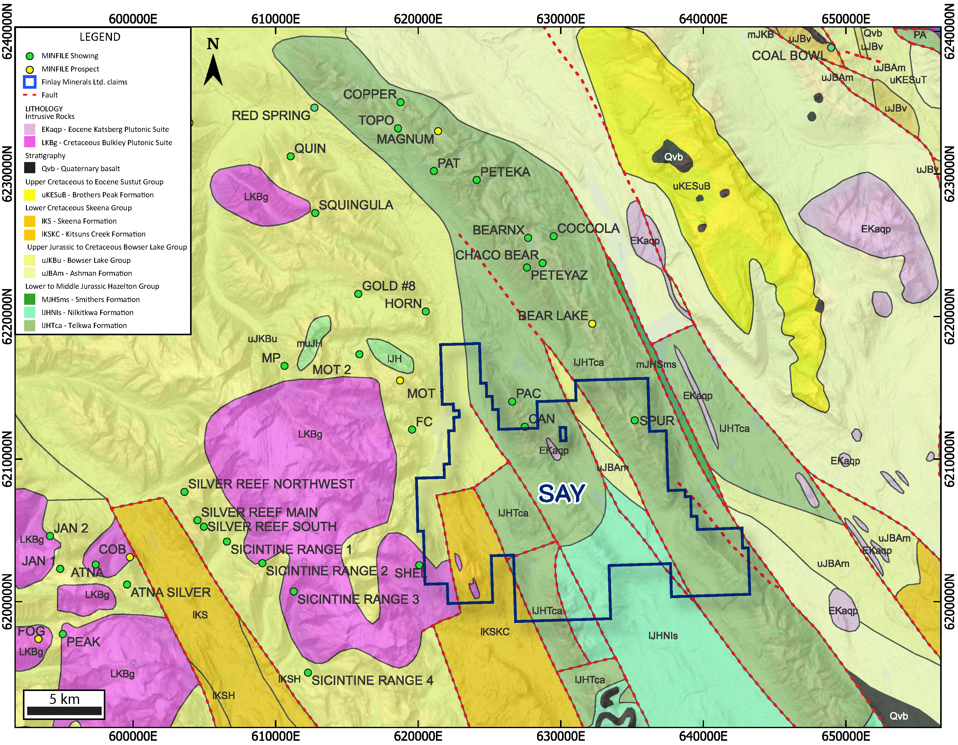
Finlay’s 100%-owned SAY Property covers 26,202 hectares (262 km2) of highly prospective Stikine Terrane, 140 km north of Smithers B.C. The Stikine Terrane is a tectonic assemblage that hosts the metal endowment in B.C.’s Golden Triangle, the Toodoggone District, and the Skeena Arch. The SAY Property straddles the western margin of the relatively underexplored, 135-km-long, “Bear Lake Corridor” of Stikinia, a tectonic position analogous to American Eagle Gold’s Nak Cu-Mo ± Ag ± Au porphyry prospect, 90 km to the south. The Bear Lake Corridor hosts several volcanic redbed / sediment-hosted Cu ± Ag showings and prospects including the Copperline and Red Spring prospects. Porphyry prospects throughout the region are associated with post-accretionary Cretaceous – Eocene intrusions in both Stikinia (e.g. Imperial Metal’s Cu-Mo Porphyry Bear Lake Project) and overlying Bowser Basin sediments to the west (e.g. HDI Quartz Mountain’s Cu Porphyry Jake Project).
SAY hosts multiple styles of Cu ± Ag and Mo-Cu mineralization in two known target areas: SPUR and SHEL. Historical assays and aeromagnetic data indicate the potential for expansion of known mineralization. Geological work by Finlay in early 2025 identified new areas of interest and additional claims were staked to expand the SAY Property to the north and south.
There is road access to the southeast end of the property, and helicopters are used to access the rest of the SAY Property.
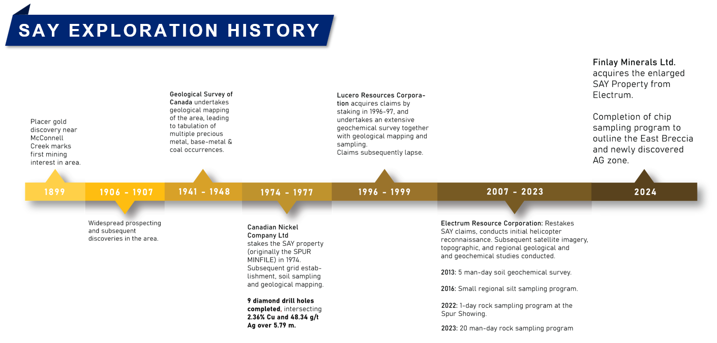
Limited historical work has identified mineralization on the SAY Property in the SPUR and SHEL target areas:
Finlay Minerals plans to complete property scale geological mapping and an aeromagnetic survey to identify viable drill targets.
SPUR Target
The eastern portion of the SAY Property covers 18.5 km of a 55-km-long NNW-trending strong magnetic high within the Stikine terrane, adjacent to the fault-bound eastern margin of the Bowser Basin. Mineralization within this magnetic trend includes the Copperline volcanic redbed Cu-Ag (“VCR”) prospect at the south end, the SPUR target area within the SAY Property, and several VCR, sediment-hosted Cu, and porphyry Cu ± Mo ± Au showings and prospects to the north.
Similar magnetic lineaments, though rarely as pronounced, are common in the broader region and are spatially associated with the Sustut VCR deposit 65 km to the north and the NAK porphyry Cu-Au-Mo prospect 90 km to the south.

SHEL
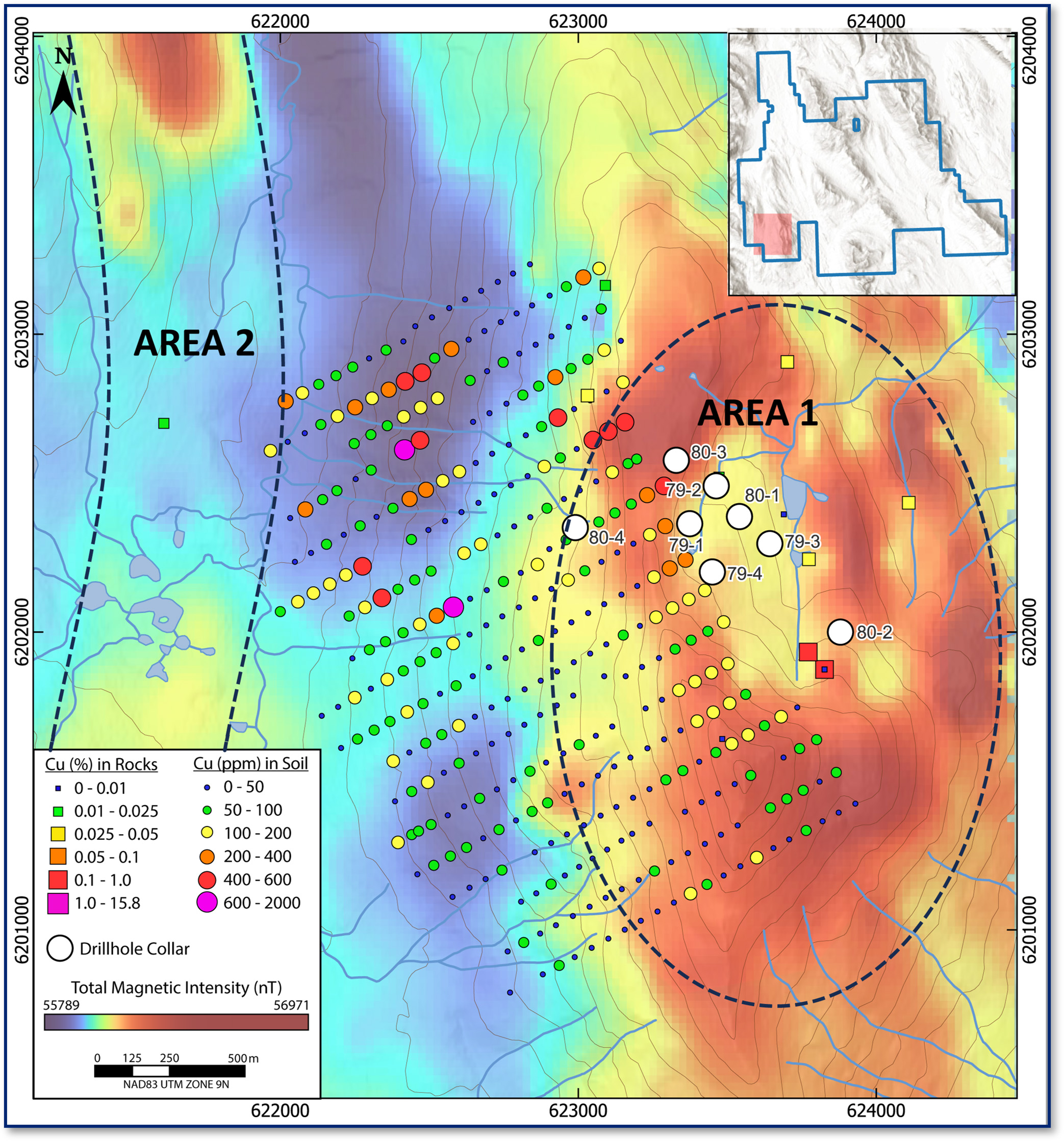
The western portion of the SAY property hosts porphyry-style mineralization with favorable geophysical targets. Porphyry-style mineral occurrences in the region are associated with post-accretionary intrusions in both the Stikine stratigraphy and overlying Bowser sediments to the west. These intrusions produce strong magnetic high anomalies in regional imagery, such as those seen west of the property and at the Jake prospect 35 km to the northwest.
In 2017, an airborne magnetic survey over the SHEL target area provided detailed imagery of two magnetic high anomalies:
The SAY Property is underlain predominantly by a NNW-trending corridor of the Stikine Terrane; the assemblage hosts several significant Cu ± Au ± Mo porphyry and associated Au ± Ag vein deposits in the Golden Triangle of Northwest B.C., in the Toodoggone district, and in the Skeena Arch of central B.C. The volcanic and sedimentary stratigraphy underlying the SAY Property belongs to the Telkwa Formation of the Lower Jurassic Hazelton Group.
Adjacent to the Hazelton Group stratigraphy, slivers of post-accretionary onlap sediments of the Upper Jurassic Bowser Lake Group and Lower Cretaceous Skeena Group are bound by faults, which may have provided pathways for mineralizing fluids.
Small felsic to dioritic intrusions in the vicinity of the SPUR showing may be assigned to the Eocene Katsberg Plutonic Suite, while stocks on the west property margin at SHEL are Cretaceous Bulkley Plutonic Suite. Porphyry-style mineralization in the region is genetically associated with both the Katsberg Suite (e.g. Bear Lake Project, Imperial Metals) and the Late Cretaceous Bulkley Plutonic Suite (e.g. JAKE Project, HDI Quartz Mountain).
In the Cretaceous and onwards, the region was subject to significant dextral transpression, which is largely responsible for the dominant NNW-trending structural fabric throughout B.C. Stratigraphy on the property is cut by dominant north-south structures and lesser northwest structures. These north-south structures exhibit possible control on the SPUR showing mineralization. A major north-south structure has been mapped regionally bisecting the property.
Structurally and stratigraphically hosted Cu-Ag mineralization in the Hazelton Group and porphyry-style Cu-Mo associated with Cretaceous and Eocene intrusions on the Property provide viable exploration targets.
While much of the central portion of the SAY property remains to be explored, mineralization is known to occur at the northeastern and western extents:
The SPUR showing is associated with disseminated and structurally hosted chalcopyrite, bornite, chalcocite, covellite with minor pyrite, occasional galena and native Cu. Malachite and azurite occurs on fractures and weathering surfaces, and as vesicle fill. High-grade, predominantly structurally hosted Cu and Ag mineralization (up to 15.8% Cu and 993 g/t Ag) has been sampled over 4.3 km along the NNW-trending Tsaytut Spur ridge. To date, 78 of 129 rock samples collected contain >1% Cu & 59 samples contain >100 g/t Ag.
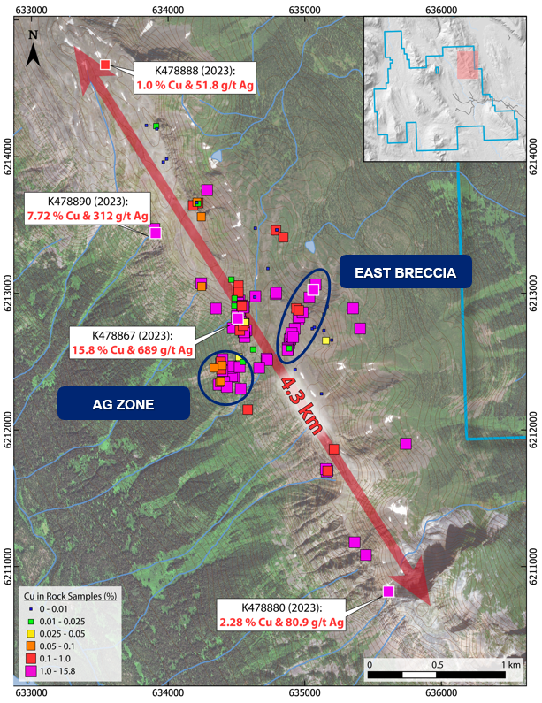
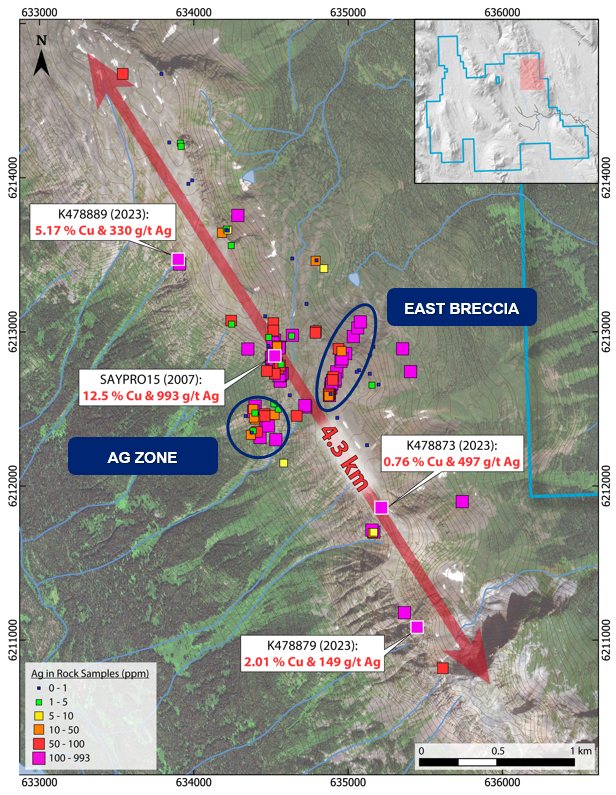
The following mineralization styles have been observed in the SPUR target area:
The SHEL showing is broadly gossanous with abundant orange and red iron-stained rocks present over ~2.5 x 1.5 km of exposed outcrop in the centre of the area. Mineralization is associated with quartz-feldspar porphyry dikes and includes chalcopyrite-molybdenite in quartz veins and in emplacement breccias along the dike margins.
Historic rock samples in the area yielded up to 1147 ppm Mo and 0.19% Cu. Shallow historic drillholes (8 drillholes for 1,616 m, maximum depth of 258 m) intersected weak Cu-Mo mineralization over tens of metres. Drillhole 79-2 intersected 59.3 m assaying 0.08% Cu and 0.107% Mo from 77.7 m (BC Mineral Assessment Report 8075). Historic exploration and geochemical anomalies lie on the western margin of a largely unexplored elliptical 3 x 2 km magnetic high.
ALTERATION
Hydrothermal alteration minerals have been observed in situ at the SPUR Target (e.g. clay, sericite, K-feldspar, chlorite, epidote). Select samples were sent for petrography, which confirmed strong clay and K-feldspar alteration (including secondary biotite) with associated sulphide and oxide minerals (chalcopyrite, malachite, geothite, covellite, chalcocite, bornite, pyrite). This evidence of hot hydrothermal fluids with biotite alteration and possible hydrothermal clays plus sulphide-bearing quartz micro veins, supports the exploration potential to link to a porphyry system.