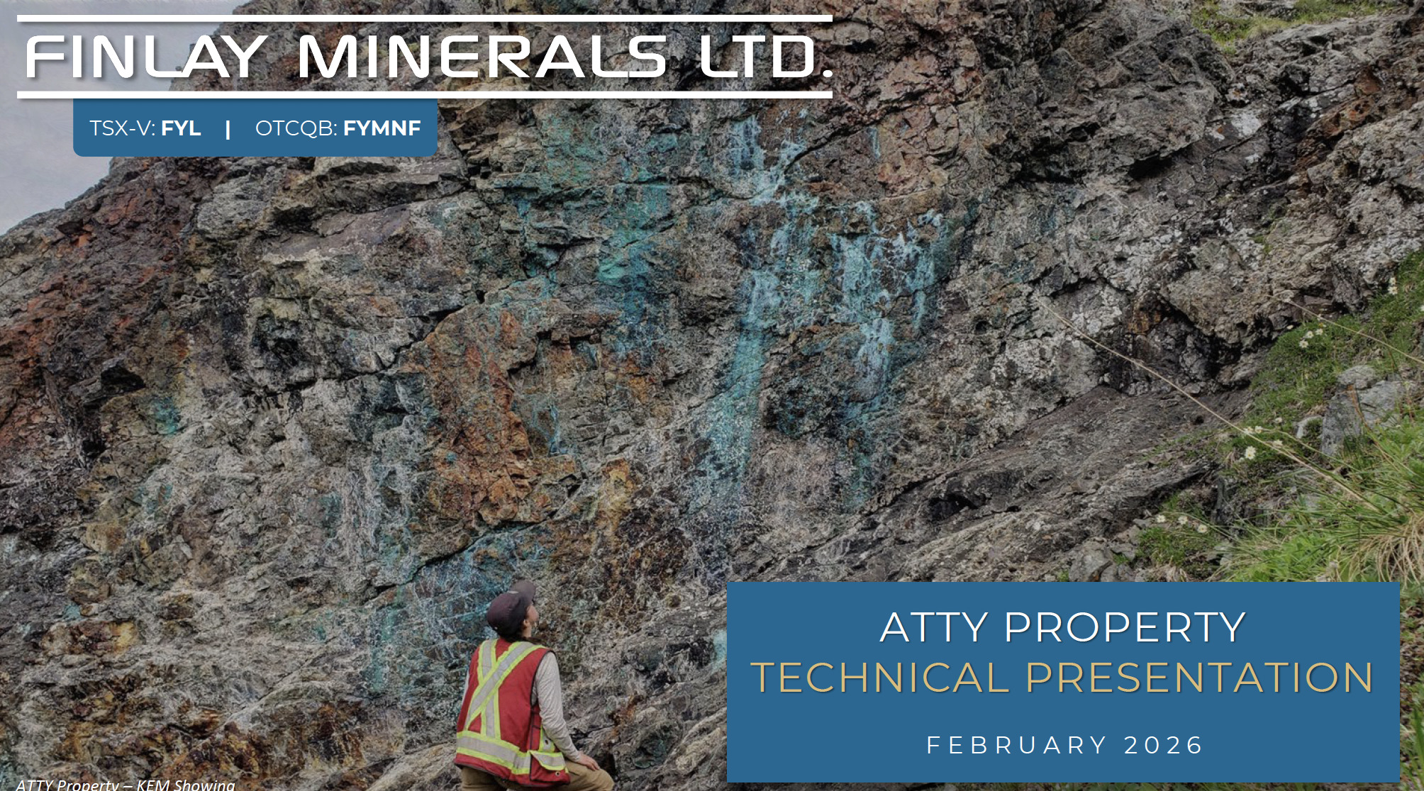
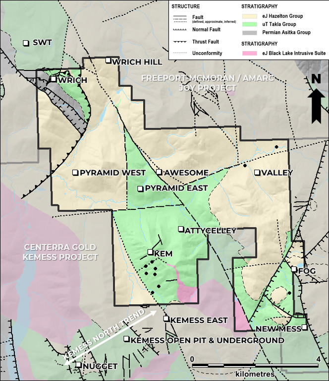
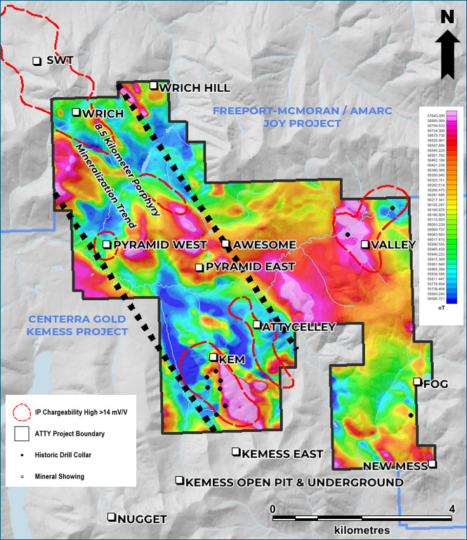
Finlay’s 100%-owned and road-accessible ATTY property covers 3,875 hectares in the prolific Toodoggone mining district of north-central British Columbia, Canada and adjoins Freeport-McMoRan/Amarc Resource’s JOY property and Centerra Gold’s Kemess Project.
On April 17, 2025, Freeport-McMoRan Minerals Canada Ltd. signed a 6 year Earn-In Agreement to acquire an 80% interest in the ATTY. The agreement will infuse a total of $10M exploration expenditures into ATTY and $1.1M cash into Finlay, with Finlay acting as the Operator for the duration of the Earn-In period. Agreement details can be found here: April 17th, 2025 News Release, May 2nd, 2025 News Release.
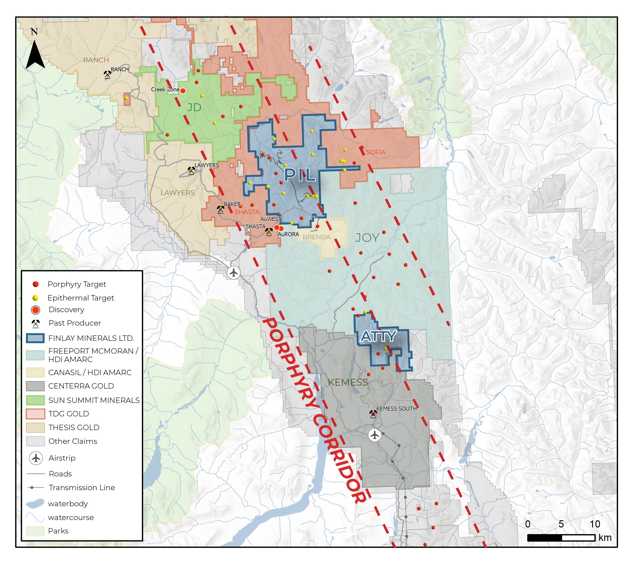
The Toodoggone is a northwest-trending belt of Triassic to Jurassic arc terranes that hosts numerous significant porphyry Cu-Au ± Ag and associated epithermal Au-Ag deposits. The northwest trending porphyry corridor through the Toodoggone District is 70 km long and includes: Centerra Gold’s past producing Kemess South Cu-Au porphyry mine and Kemess Underground, Open Pit and East Cu-Au-Ag porphyry resources, Thesis Gold’s Lawyers-Ranch Au-Ag epithermal resource, and the newly discovered Freeport-McMoRan and Amarc Resources’ AuRORA Cu-Au-Ag porphyry.
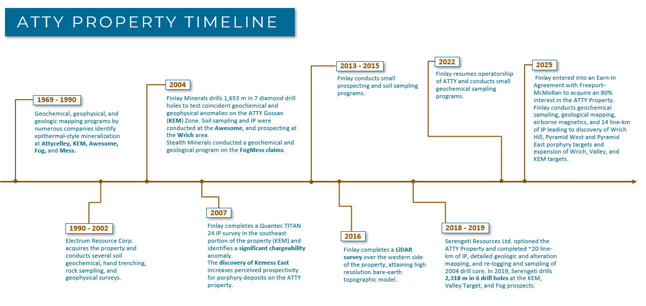
In 2025, Finlay conducted geochemical sampling, geological mapping, airborne magnetics, and 14 line-km of IP on the ATTY Property leading to the discovery of the Wrich Hill, Pyramid West, and Pyramid East porphyry targets and the advancement of the Wrich, Valley, and KEM porphyry targets and the Attycelley epithermal target. Details can be found in the January 14, 2026 News Release. Planning is underway for a significant 2026 exploration program.
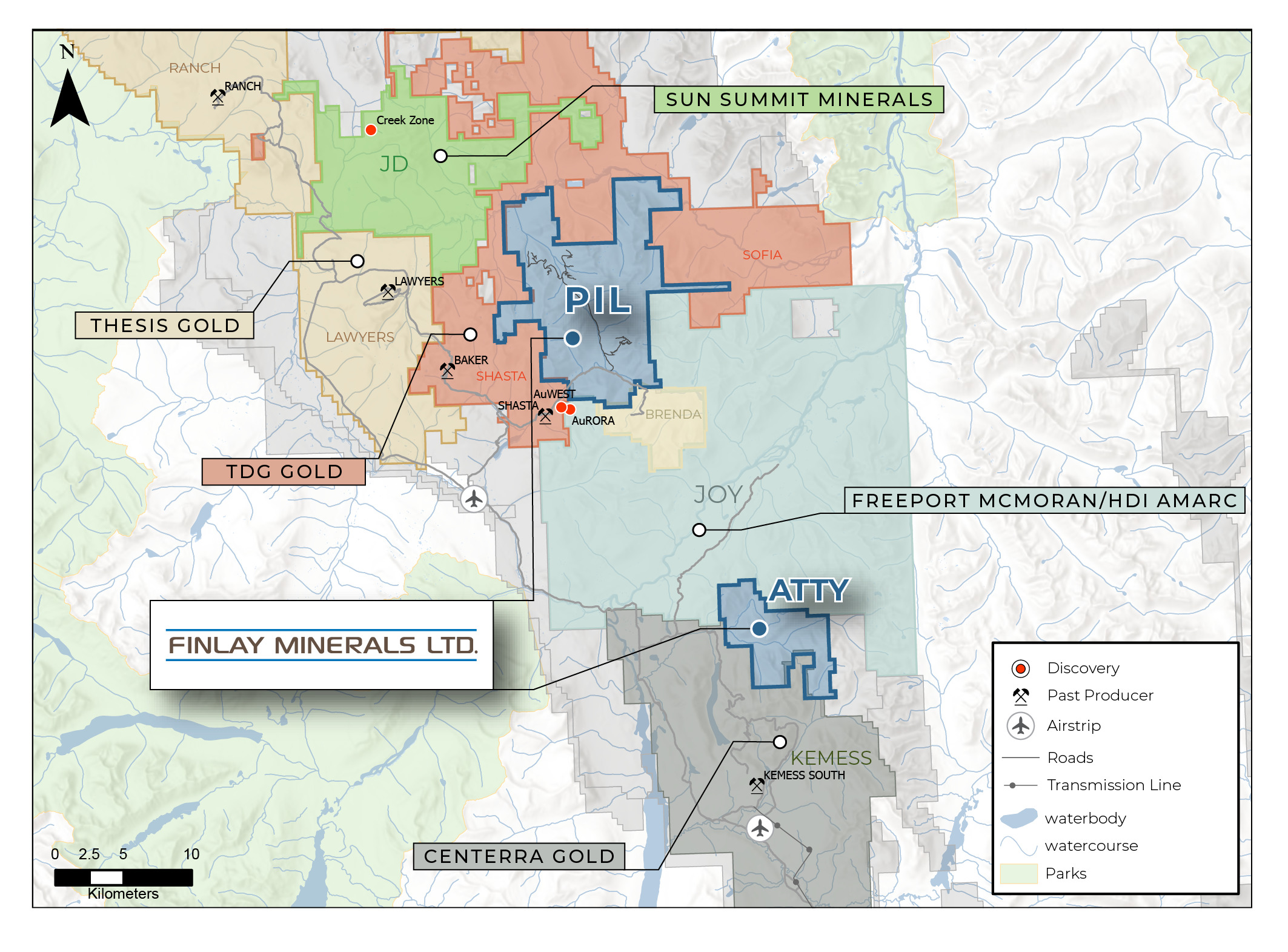
ATTY hosts favourable geology with a setting similar to the Kemess North Trend, which hosts the Kemess Underground, Kemess Open Pit and Kemess East Deposits, and the AuRORA porphyry target on Freeport McMoran and Amarc’s JOY property.
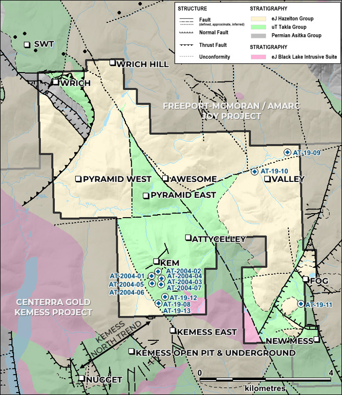
ATTY is underlain by three unconformably bound successions: sedimentary rocks of the Permian Asitka Group, and volcanic rocks of the Upper Triassic Takla Group and Lower Jurassic Hazelton Group.
Permian Asitka Group rocks are preserved in a small area on the northwestern portion of the Property consisting of chert, siltstone, and mudstone, and are overlain by two volcanic sequences of the Upper Triassic Takla Group: 1) pyroxene-phyric mafic flows interbedded with subordinate mafic ash tuffs and volcanic wackes; and 2) a unit of massive mafic lapilli fragmental volcanics. Lying unconformably on top of Takla units are four sub-units of the Lower Jurassic Hazelton Group, which are composed of, from bottom to top, 1) a mafic volcaniclastic and epiclastic unit with course fragments and clasts of Takla Group units, 2) mafic tuffs, 3) intermediate volcaniclastics and epiclastics, and 4) hematitic mafic crystal tuffs.
The volcanic units at ATTY are intruded by granodiorite, monzonite, and syenite stocks and dykes of the Early Jurassic Black Lake Suite. These units are variably altered medium-grained intrusions containing quartz, plagioclase and hornblende.
Major northwest-trending structures transect the property and are truncated by steep northeast to east trending faults. Regionally, the intersection of these form conduits for mineralizing intrusions resulting in northeast trending alignments of porphyry mineralization. Takla volcanic and sedimentary units are consistently upright and young toward the northeast, while Jurassic units appear relatively flat lying. Stratigraphy has been offset by horst-and-graben style block faulting and lesser late (Eocene) shallowly dipping north-vergent thrusts.
The ATTY Property hosts ten (10) known Cu ± Mo ± Au porphyry and Au-Ag epithermal mineral occurrences, three of which were discovered during the 2025 field season. Only three targets have been tested with limited drilling, which intersected large alteration zones interpreted to be associated with porphyry and epithermal systems.

KEM-ATTYCELLEY
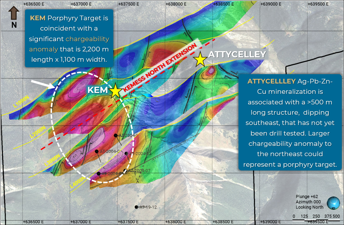
KEM and Attycelley targets are located 1.8 km north of the Kemess North Trend, which hosts Centerra Gold’s Kemess Underground, Open Pit and East Cu-Au-Ag porphyry deposits, and were discovered in the early 1970’s. Historical work focused on high-grade epithermal veins and recent geological mapping, geophysical surveys, and review of historical drill core has highlighted the potential for a porphyry system with a footprint of multiple square-kilometers that has not been thoroughly tested.
The KEM target is a 1,000 m by 2,200 m IP chargeability high within a larger 3,000 m by 3,000 m Cu-Au-Ag soil geochemical anomaly that includes the Attycelley epithermal and porphyry target.
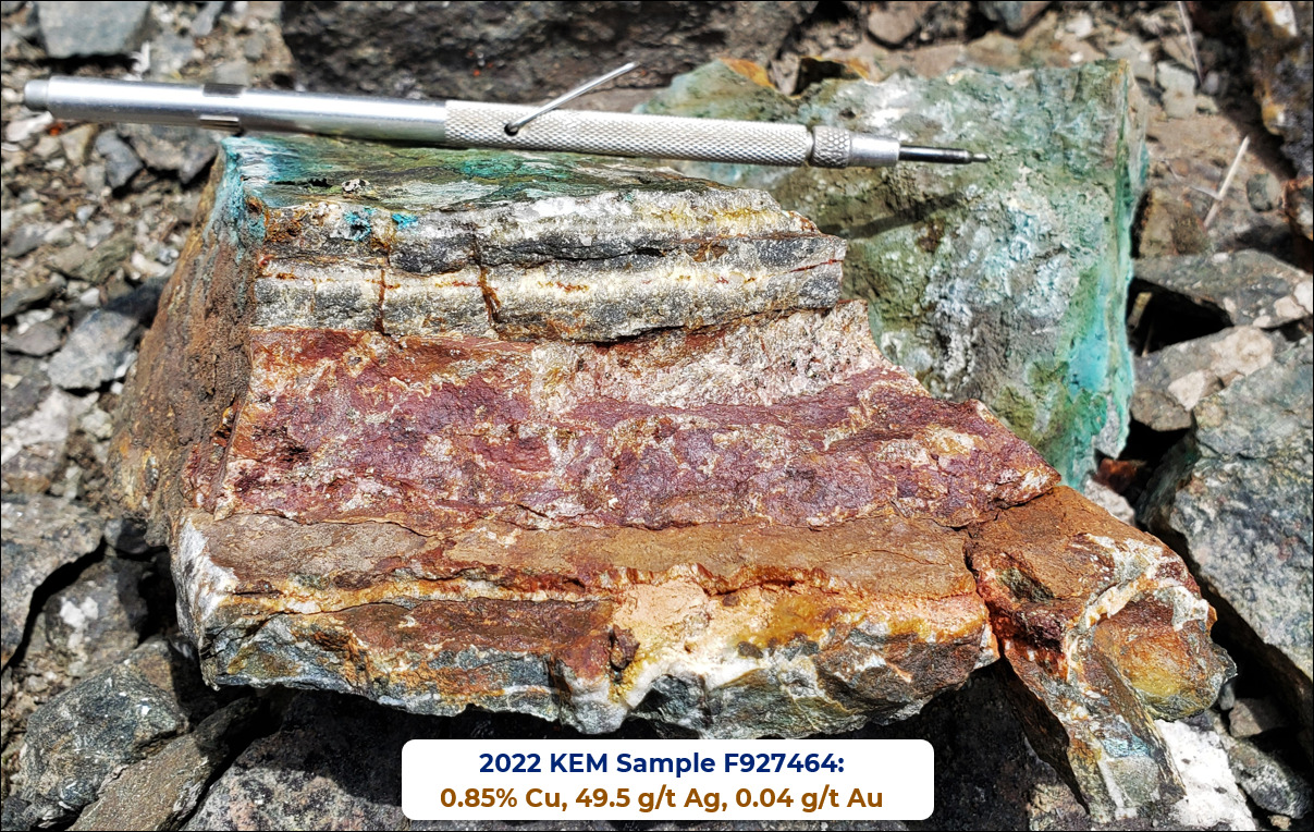
At surface, mineralization at KEM consists of multiphase quartz-carbonate-chalcopyrite-malachite-pyrite veins (Cu-Ag-Au) that range in thickness from 5 cm – 2.0 m and trend subparallel to topography for > 1 kilometer with rock samples returning grades up to 28.5 g/t Au, 1026.9 g/t Ag, 9.90% Cu, 0.582% Mo, 2.62% Pb, and 7.71% Zn. To the east at Attycelley, Ag-Pb-Zn-Cu mineralization is associated with a >500 m long structure, dipping southeast, that is open along strike and has not yet been drill tested. Decimeter- to meter-scale polymetallic quartz-barite veins have returned up to 1.78% Cu, 0.842 g/t Au, 240 g/t Ag, 4.55% Pb, and 10.5% Zn.
Alteration mapping and hyperspectral studies show an increase in the intensity of propylitic alteration northward, with exposures of weak potassic alteration in the far north. At depth, drilling has intersected sheeted magnetite-chalcopyrite veinlets with K-feldspar halos.
The broad multi-km2 geochemical anomaly, coincident geophysical anomaly, and higher temperature alteration identified in drill core and on surface are indicative of a porphyry system at depth. The KEM-Attycelley target is drill-ready and a high-priority target for 2026.
WRICH
The Wrich Cu-Au porphyry target is the extension of the SWT target to the north on Freeport McMoRan and Amarc’s joint ventured JOY Property. Field work in 2025 has expanded the extents of the target area and defined a 1,200 m x 1,200 m Cu-Au-Ag-Mo soil geochemical and chargeability anomaly. The geochemical and chargeability anomalies are mostly associated with mapped Takla Group volcanics, which are a favorable host for Cu-Au porphyries in the Toodoggone, such as the Kemess Cu-Au porphyry deposits. Drilling at SWT in 2022 by Freeport-Amarc returned local zones of anomalous Cu-Au compatible with proximity to a porphyry system (e.g. 78 m of 0.02% Cu, 0.11 g/t Au, 0.04 g/t Ag in JP22028). (1)
On the southeast side of the target area, rock samples of vuggy quartz veins returned 0.54 g/t Au and 99.7 g/t Ag.
WRICH HILL
The Wrich Hill target is a new target defined by a 1,200 m by 600 m Au-Bi-Pb-Te-Zn in soil geochemical anomaly associated with a magnetic low. This target area could represent a higher-level signature of a Cu-Au porphyry system. Immediately north of the Wrich Hill target on the JOY Property, Freeport and Amarc intersected Au-Ag-Cu mineralization in 2022 with 108 m 0.03% Cu, 0.23 g/t Au, 6.4 g/t Ag in JP22044 in correlation with advanced argillic alteration zones. (1)
PYRAMID
The Pyramid Cu-Au porphyry target can be split into a west and east section. Pyramid West hosts a 200 m by 200 m Cu-Au-Mo-Te soil geochemical anomaly, open to the north. A single IP line resulted in a 500 m chargeability high truncated by a fault to the south. This chargeability anomaly extends to the east where another IP line show a slightly more subdued chargeability anomaly.
Pyramid East shows a continuous IP chargeability high that could connect to the Wrich target. This IP anomaly trends southeast to an 800 m by 850 m Cu-Au soil geochemical anomaly and a circular magnetic anomaly. The geochemical anomaly is located due south of the Awesome epithermal Au showing.
VALLEY
The Valley target contains a large IP chargeability anomaly over 1,800 m in length, most of which is at valley bottom with little outcrop exposure. A single IP line completed in 2025 extended the chargeability anomaly an additional 500 m to the southeast.
The target was tested in 2019 with two drill holes, where anomalous Au-Cu occurs within coarse monzonite and Takla Group volcanic units with pyrite and trace chalcopyrite-molybdenite. Alteration consists of propylitic, phyllic, and patchy potassic alteration and could indicate proximity to a porphyry system.
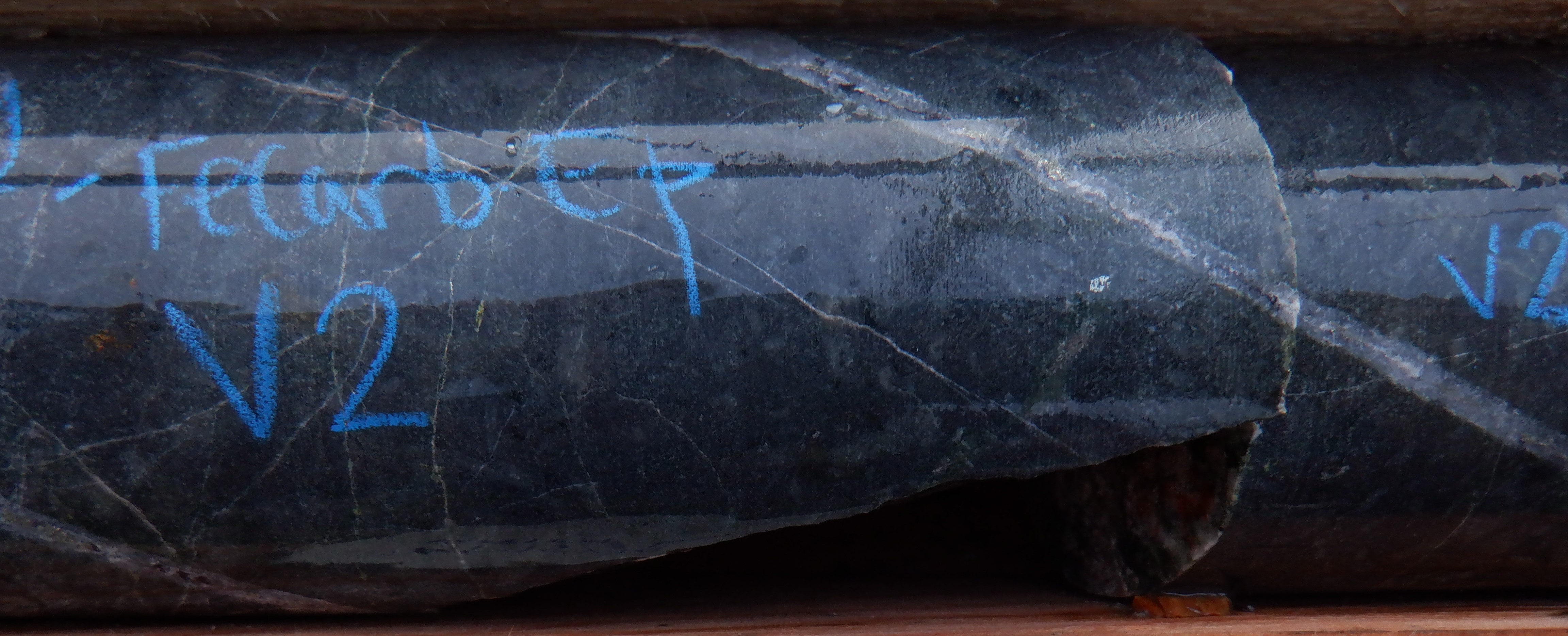
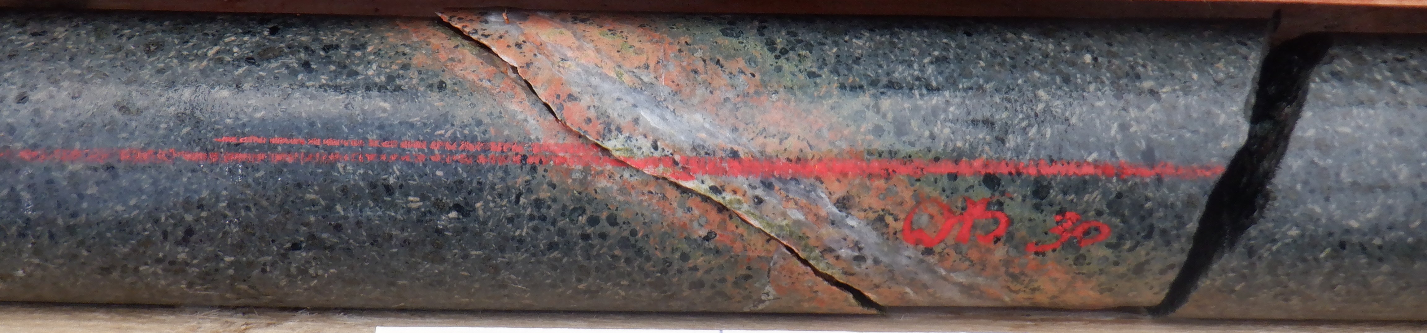
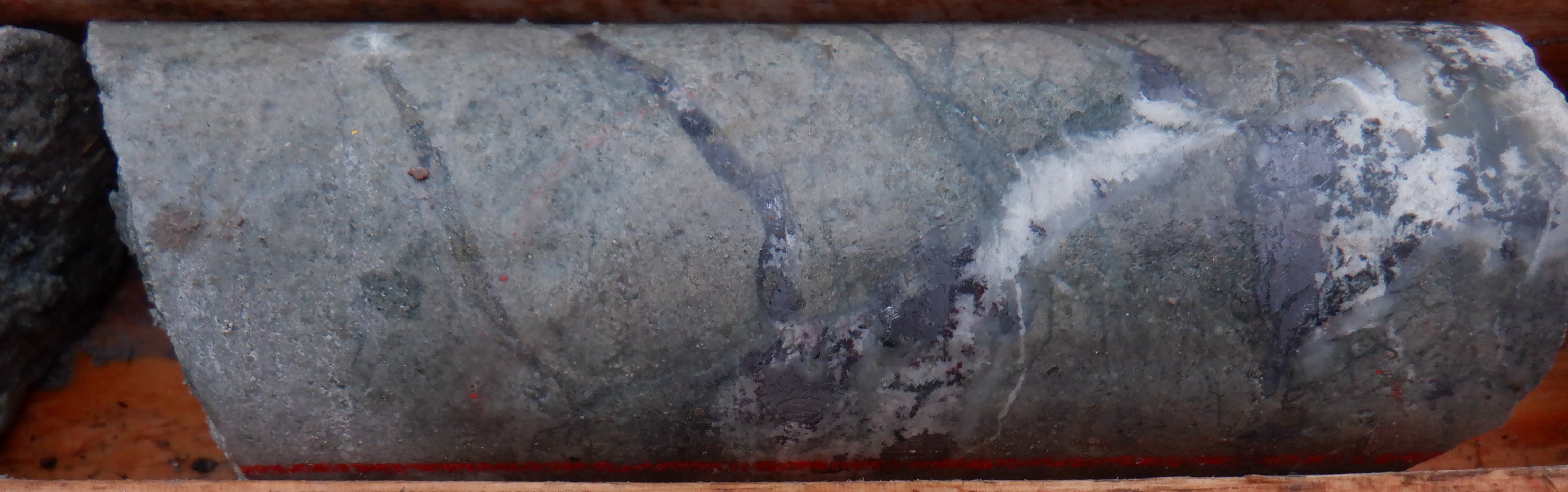
Valley drill hole AT-19-10 at 344.6 m: quartz-pyrite-chalcopyrite-magnetite-molybdenite veinlet.
AWESOME, FOG, NEW MESS
In the central and southeastern portions of the property are the Awesome, Fog, and New Mess early-stage epithermal Au-Ag targets.
Awesome has seen trenching and rock sampling returning up to 4.3 g/t Au and 404 g/t Ag. At Fog-New Mess, rock sampling of structurally hosted pyrite-chalcopyrite-Cu-oxide mineralization in areas of intense silica alteration returned up to ≥1.0% Cu, 3.01 g/t Au, 219 g/t Ag, 12.7% Pb, and 10.6% Zn. Geological mapping has suggested that this surface mineralization may be related to a porphyry system at depth. Below the surface mineralization is an associated chargeability anomaly. Drilling intersected intermittent epithermal-style veining with modest mineralization.
Several ground-based induced polarization (IP) and airborne magnetic surveys have been completed on the ATTY Project with more IP lines proposed for 2026.
Induced Polarization Surveys
Ground-based induced polarization surveys are a common and effective method of identifying sulphide mineralization, intrusive bodies, and major structures at depth. IP surveys are particularly useful in outlining lithocap environments found at the top of porphyry systems and have led to several discoveries in the Toodoggone region.
IP surveys were completed on the ATTY property in 2007, 2018, 2019, and 2025, and were successful in identifying large chargeability anomalies (>14 mV/V) at the Wrich, Pyramid, KEM, Attycelley, Valley, and Fog-New Mess target areas, many of which are associated with broad soil anomalies and/or strongly anomalous rock samples.
At KEM-Attycelley, chargeability and resistivity features display a fault block model similar to the Kemess North Trend. The chargeability anomaly at the KEM target occurs below mineralized veins where hyperspectral studies show good porphyry potential and have identified areas for drill-testing. At Attycelley is an untested chargeability anomaly that is also drill-ready.
2025 Airborne Magnetics
543 line-km of airborne magnetics was completed during the 2025 field season providing detailed coverage of the ATTY property.
Airborne magnetic surveys are a useful exploration tool for porphyry deposits, which generally exhibit characteristic alteration aureoles with associated geophysical responses. The results of the 2025 survey show favourable signatures for porphyry deposits and mineralized linear structures on the ATTY property:
Of the 10 porphyry and epithermal targets on the property, only three have been drill tested. Two drill campaigns were completed at ATTY in 2004 and 2019, consisting of 13 holes totalling 3,971 m. Drilling on the property intersected broad zones of hydrothermal alteration and anomalous Cu-Au indicating proximity to porphyry centers. The project is currently drill permitted and the KEM and Attycelley targets are drill-ready. The 2026 exploration program will be designed to advance the remaining targets towards drilling.
KEM
Ten drill holes have been collared at KEM to test the Kemess North Extension potential. The current interpretation based on recent 3D geological modeling by Finlay is that previous drilling was not conducted deep enough to test the underlying 1,000 m x 700 m IP chargeability anomaly. The alteration and lithology observed in core at KEM are similar to the upper portion of the Kemess East deposit.
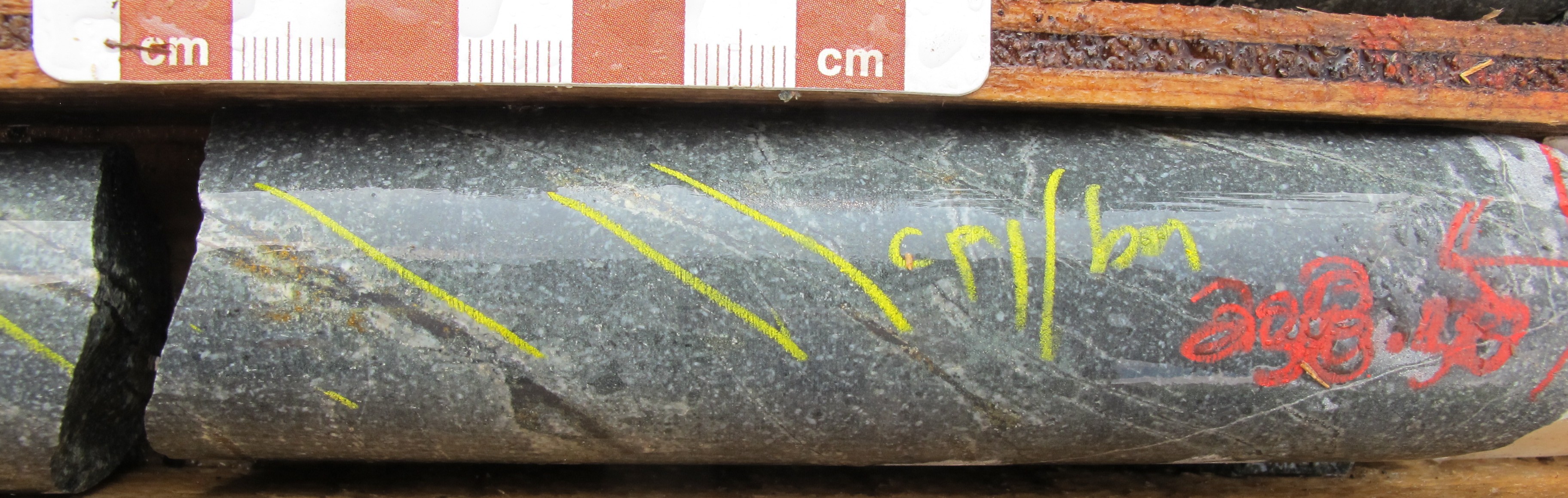
KEM drill hole AT-2004-7 at 238.5 m: chalcopyrite-bornite veinlets.
VALLEY
Drilling at Valley targeted an intense chargeability anomaly with two holes spaced ~1135 m apart in an area with minimal outcrop exposure. Drill holes AT-19-09 and AT-19-10 intersected coarse-grained monzonite and Takla volcanic rocks with significant pyrite and varying propylitic, phyllic, and potassic alteration.
The presence of widespread alteration with quartz-pyrite ± chalcopyrite ± molybdenite and pyrite-chalcopyrite veining indicate drilling has intersected the periphery of a porphyry system. The 2019 IP and drilling were the first work done on the Valley Target. An IP survey completed in 2025 extended the chargeability anomaly 500m to the southeast with results warranting further work.
Valley drill hole AT-19-09 at 459.5 m: quartz-pyrite vein with potassium-feldspar and epidote halo hosted by propylitically altered Takla.
Fog-New Mess
A single drillhole tested an area of silica-flooded pyrite-chalcopyrite-Cu-oxide bearing zone and strong chargeability anomaly identified by geological mapping and an IP geophysics survey in 2018. The hole intersected several intervals with elevated Au-Ag-Pb-Zn, predominantly in epithermal-style veins and vein breccias cutting propylitically altered Takla Group volcanics.
Fog-New Mess drill hole AT-19-11 at 369 m: quartz-galena-pyrite-chalcopyrite-sphalerite vein with calcite infill.